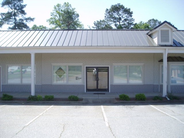
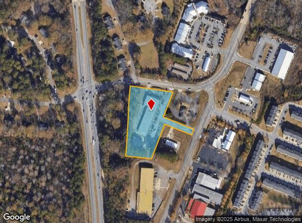
Property Record
8801 Macon Hwy, Athens, GA 30606
NEARBY LISTINGS FOR SALE OR LEASE
Property Detail
8801 Macon Hwy
C02-0-44A
910/289-290 186/39 ;
Stripcommercialcenter
Oconee
X
Georgia
13059C0034F
2.60 AC
2024
South Athens
2024
Other Market Areas
030201
Athens-Clarke County, GA
16,504 SF
DEMOGRAPHICS near 8801 Macon Hwy
1 Mile
3 Mile
5 Mile
2024 Total Population
3,110
40,241
111,299
2029 Population
3,292
41,285
113,772
Pop Growth 2024-2029
+ 5.85%
+ 2.59%
+ 2.22%
Average Age
34
34
35
2024 Total Households
1,145
14,877
44,200
HH Growth 2024-2029
+ 5.59%
+ 2.56%
+ 2.00%
Median Household Inc
$58,795
$62,274
$54,624
Avg Household Size
2.60
2.30
2.20
2024 Avg HH Vehicles
3.00
2.00
2.00
Median Home Value
$356,122
$376,010
$302,389
Median Year Built
1992
1986
1987
Nearby Places
Map Layers
Map Styles
 Street
 Aerial
- Restaurants
- Banks
- Shops
- Fitness
- Groceries
Nearby Properties
Address
Land Use
TOTAL SIZE
Lot Size
Zoning
Address
Land Use
TOTAL SIZE
Lot Size
Zoning
49.33 AC
G
Address
Land Use
TOTAL SIZE
Lot Size
Zoning
35 AC
G
Address
Land Use
TOTAL SIZE
Lot Size
Zoning
47.56 AC
G
Address
Land Use
TOTAL SIZE
Lot Size
Zoning
2,094.97 AC
G
Address
Land Use
TOTAL SIZE
Lot Size
Zoning
16.60 AC
G
Address
Land Use
TOTAL SIZE
Lot Size
Zoning
122,400 SF
12.51 AC
G
Address
Land Use
TOTAL SIZE
Lot Size
Zoning
21.04 AC
G
Address
Land Use
TOTAL SIZE
Lot Size
Zoning
5.49 AC
G
Address
Land Use
TOTAL SIZE
Lot Size
Zoning
20 AC
G
Address
Land Use
TOTAL SIZE
Lot Size
Zoning
17.23 AC
G
Address
Land Use
TOTAL SIZE
Lot Size
Zoning
6.15 AC
G
Address
Land Use
TOTAL SIZE
Lot Size
Zoning
97,317 SF
24.31 AC
C-G
Address
Land Use
TOTAL SIZE
Lot Size
Zoning
11,600 SF
154.32 AC
AR
Address
Land Use
TOTAL SIZE
Lot Size
Zoning
26.76 AC
G
Address
Land Use
TOTAL SIZE
Lot Size
Zoning
18.47 AC
C-G
Address
Land Use
TOTAL SIZE
Lot Size
Zoning
66,200 SF
13.35 AC
G
Address
Land Use
TOTAL SIZE
Lot Size
Zoning
28.29 AC
G
Address
Land Use
TOTAL SIZE
Lot Size
Zoning
6.01 AC
G
Address
Land Use
TOTAL SIZE
Lot Size
Zoning
5.91 AC
G
Address
Land Use
TOTAL SIZE
Lot Size
Zoning
101,920 SF
18.01 AC
RM-2
Address
Land Use
TOTAL SIZE
Lot Size
Zoning
1,956 SF
93.87 AC
RM-1
Address
Land Use
TOTAL SIZE
Lot Size
Zoning
16.58 AC
G
Address
Land Use
TOTAL SIZE
Lot Size
Zoning
4,373 SF
25.41 AC
RM-2
Address
Land Use
TOTAL SIZE
Lot Size
Zoning
19.92 AC
G
Address
Land Use
TOTAL SIZE
Lot Size
Zoning
1,672 SF
23.70 AC
RM-2
Address
Land Use
TOTAL SIZE
Lot Size
Zoning
3,617 SF
22 AC
RM-1
Address
Land Use
TOTAL SIZE
Lot Size
Zoning
38,928 SF
18.56 AC
RM-2
Address
Land Use
TOTAL SIZE
Lot Size
Zoning
48,400 SF
12 AC
RM-2
Address
Land Use
TOTAL SIZE
Lot Size
Zoning
3 AC
G
Address
Land Use
TOTAL SIZE
Lot Size
Zoning
153.94 AC
G
The World's #1 Commercial Real Estate Marketplace
Connect with us
© 2025 CoStar Group
The information above has been obtained from sources believed reliable. While we do not doubt its accuracy we have not verified it and make no guarantee, warranty or representation about it. It is your responsibility to independently confirm its accuracy and completeness. Any projections, opinions, assumptions, or estimates used are for example only and do not represent the current or future performance of the property. The value of this transaction to you depends on tax and other factors which should be evaluated by your tax, financial, and legal advisors. You and your advisors should conduct a careful, independent investigation of the property to determine to your satisfaction the suitability of the property for your needs.